
Stream Restoration

Dry Creek Collaborative Restoration Project
Connecting people and fisheries to improve ecosystem resilience
(May 2019) Written by Kelsie Dougherty, GWC Education & Outreach Committee Volunteer
“A few years ago I had the privilege of working with Greater Gallatin Watershed Council as a Stream Team volunteer on the East Gallatin River supporting local water quality monitoring efforts. That experience enhanced my connection to this place in a way that goes beyond community, I felt like I was making a meaningful impact and contributing to something bigger than my backyard stream.
Fast forward several years and I am again volunteering with GWC to plant native willows on a portion of Dry Creek, a tributary to the East Gallatin River north of Belgrade. Dry Creek has been on the Department of Environmental Quality’s List of Impaired Waters since 1992 because of its high sediment load associated with channel realignment, reduced riparian vegetation, and land use practices. In order to meet state water quality standards, the DEQ declared that Dry Creek needed a 31% reduction in sediment loading from the eroding streambanks. This willow planting project will help stabilize the banks of a recently restored section of the stream, and it’s just one step of the project. Lucky for us, it was a clear sunny day amidst weeks of variable spring weather and we were all in good spirits, ready to get dirty and have some fun.
Our day began with an overview of the project from partners at Trout Unlimited and then we headed out to the site to get muddy. Jeff Dunn, the TU Upper Missouri Project Manager, explained that planting willows is an effective way to rejuvenate riparian habitat and stabilize banks. As the root system of the willows establish multiple feet underground and into the groundwater table, it provides a network of stability for the soil and improves the stream’s ability to withstand future flood events. The riparian buffer created from these willows will absorb pollutants, keeping them out of the streams and ultimately improving water quality. Resilient creeks are better for both fish and people.
Dry Creek drains the west slope of Bridger Range and the Horseshoe Hills before flowing into the East Gallatin River, a major tributary of the Gallatin River. It is an important cold-water refuge for native trout during the warm summer months when the East Gallatin is at risk of seasonal low-flows and temperature spikes. Historically, ditch building and cattle grazing have created a wide and shallow stream that has heavily impacted the ecological function of the creek. Shallow water warms in the summer sun and trout need access to cool waters in order to thrive. Without fencing to protect vulnerable riparian areas, banks get trampled and sediment can pollute the water, creating an uninviting habitat for trout eggs.

Using a water jet stinger to bore holes into the creek banks, several groups of volunteers planted over a thousand willow cuttings along a mile-long reach of streambank in a pattern that will allow wildlife access to the stream as the vegetation takes hold. Establishment of this vegetative cover will ensure that this tributary remains a sanctuary for cold water fish by lowering stream temperatures, reducing erosion, and creating habitat. This project is getting us one step closer toward meeting the goals listed in the Lower Gallatin Watershed Restoration Plan and delisting Dry Creek as an impaired waterbody. Volunteering on watershed projects in the community that effect meaningful change is such a rewarding experience, not to mention the people who come out to help are also a great crowd. Watersheds connect communities and volunteering connects people and improves community resilience.”
Story Mill Community Park
A success story of stream restoration and wetlands protection
Located on the north side of Bozeman, adjacent to the historic flour mill, Story Mill Community Park opened in 2019 with playgrounds, sports fields, and hiking trails.
The Greater Gallatin Watershed Council worked with The Trust For Public Land, the City of Bozeman, and other partners to enhance habitat and water quality at Story Mill Park. In early summer of 2016, the stream restoration project funded in part by the Montana Department of Environmental Quality was completed. You can view a photo journal of the restoration construction process by clicking here.
More than a century of activity at this agricultural hub resulted in changes to the natural landscape at the confluence of Bozeman Creek and the East Gallatin River. Both streams became heavily impacted by urban and agricultural activities, and neither met state water quality standards. The wetlands was one of the only remaining in urban Bozeman, although it was no longer functioning effectively as wildlife habitat or a water quality filter. Wetlands and floodplains provide important habitat for fish and wildlife and enhance water quality in rivers.
Through collaborative community effort, the critical watershed features at Story Mill Park have now been restored, so the site can again be what it was 150 years ago—a thriving habitat for plants, animals, water, and people.
Today, the southern portion of the 60-acre park will permanently remain a natural area with restored wetlands, home to bird and wildlife watching opportunities, and accessible by trails and boardwalks.


Map of restoration at Story Mill Park (click to enlarge)
Bozeman Creek Enhancement Project
Working to restore our local Bozeman Creek to a healthy, continuous stream corridor
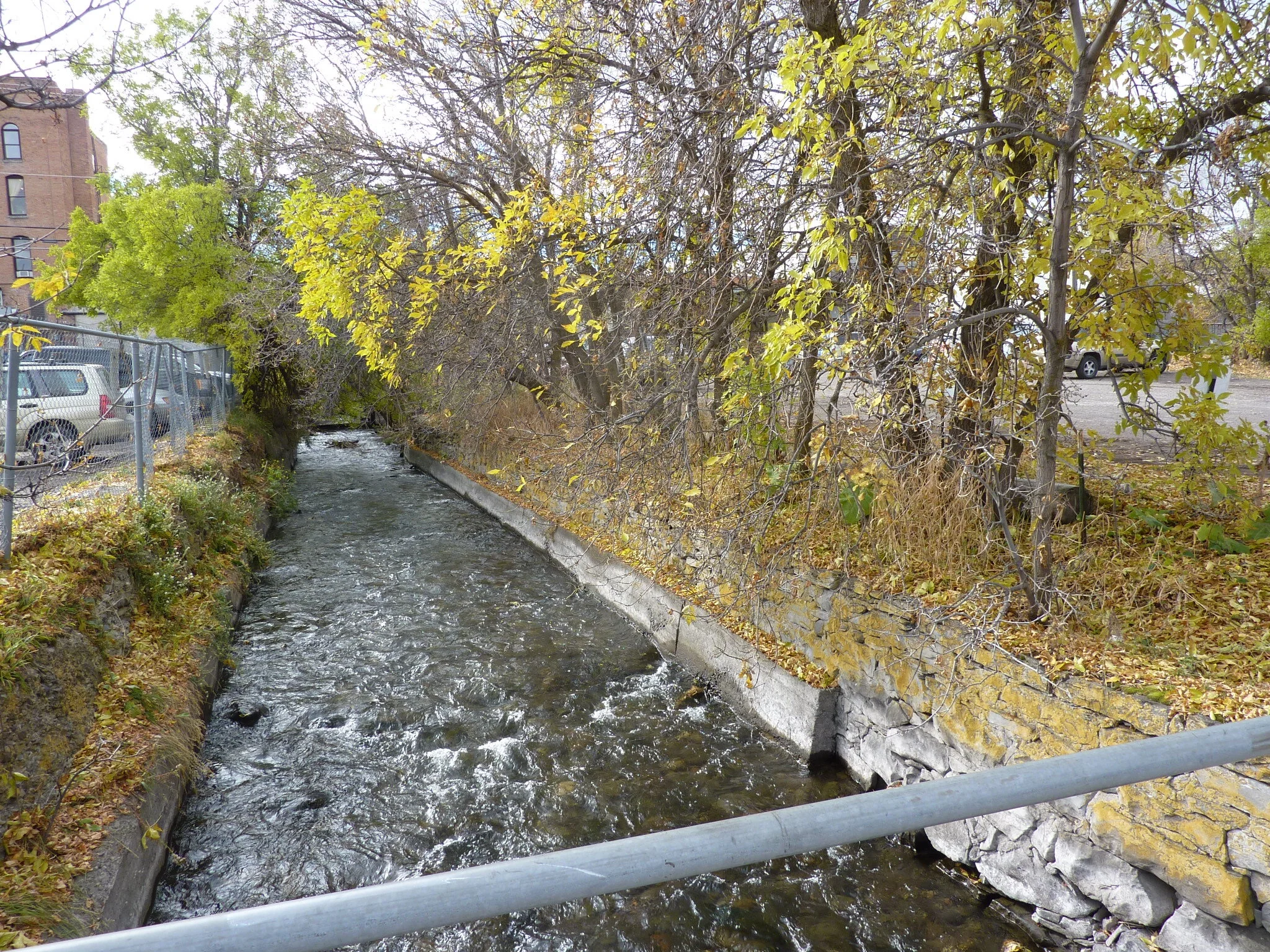
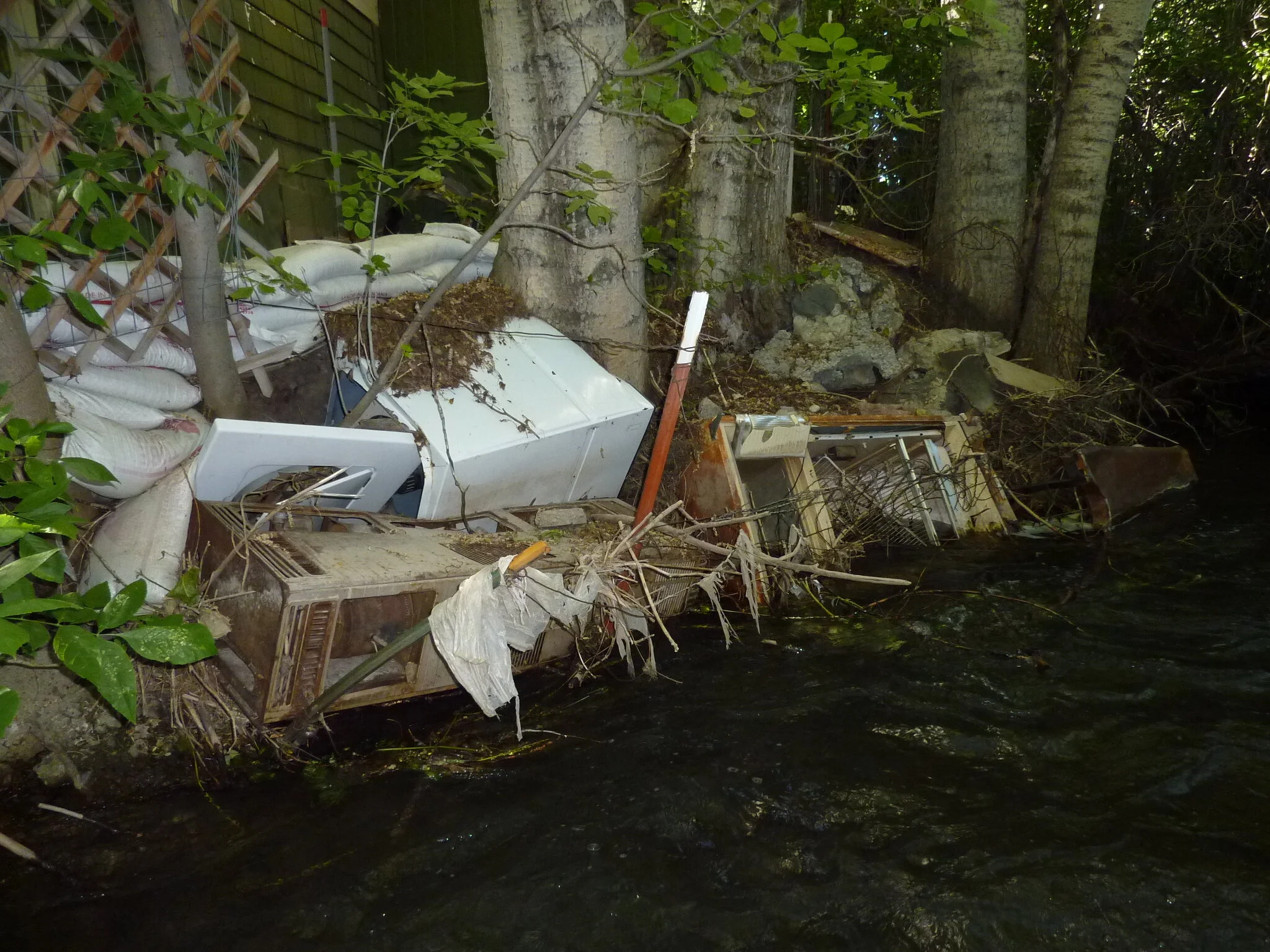
Running through the heart of the city of Bozeman, Bozeman Creek has been narrowed and straightened, its banks armored with rock and concrete, and its riparian vegetation removed or reduced to a thin green line. Downtown, the creek runs underground beneath streets and buildings. Elsewhere in the urban core, the creek is girdled by parking lots and other developments.
Localized flooding occurs routinely. Numerous low bridges cause backwater effects during high water events and present the risk of significant flooding if blocked by debris. The creek’s water quality suffers from pollutants in stormwater run-off and the fishery is far below its potential. Public access to the creek is minimal. Bozeman Creek in its current condition is a marginalized and under-appreciated resource with huge potential to be a central asset to the community.

The Bozeman Creek Enhancement Project is being undertaken by a partnership of community groups, city and agency staff, and individuals to improve the value of Bozeman Creek as a community asset. The Bozeman Creek Enhancement Committee (BCEC) includes representatives from the Bozeman Parks and Recreation Department; Downtown Bozeman Partnership; Friends of Bogert Park; Gallatin Local Water Quality District; Gallatin Valley Land Trust; Greater Gallatin Watershed Council; Montana Fish, Wildlife and Parks; Trout Unlimited’s Madison-Gallatin Chapter; and professional firms and landowners. The BCEC receives planning and technical assistance from the National Park Service’s Rivers and Trails Program.
The project is focused on the six miles of the creek that flow through the jurisdictional boundaries of the city of Bozeman to the creek’s confluence with the East Gallatin River. From its headwaters in the Gallatin National Forest through the agricultural lands to south of the city, the creek is in relatively good shape. Significant resource impacts begin as the creek enters the residential areas on the edge of town and greatly worsen as the creek flows through the urban, then industrial, areas.
Bozeman Creek Enhancement Plan
Through a two-year process of collaborative planning and substantive public involvement, the Bozeman Creek Enhancement Committee worked to develop a long-term enhancement plan for the creek, while simultaneously working to identify and implement priority early-action projects. In 2012, the Bozeman City Commission voted to adopt the Bozeman Creek Enhancement Plan as official city policy.
Vision
BCEC envisions Bozeman Creek as a focal point of our quality of life, with a healthy and continuous stream corridor. We are a community with a culture of stewardship and awareness of the creek and its values, and we support:
A naturally functioning and connected creek corridor with healthy riparian areas and floodplains
An aquatic environment that supports a vigorous plant and animal community
Clean water for people and wildlife
A safe and beautiful recreational corridor with ample public access
Integrating this valued asset into community planning and design, contributing to a vibrant downtown.
Project Goals
Goal 1: Foster broad awareness of and appreciation for Bozeman Creek, leading to a strong community stewardship ethic.
Goal 2: Restore the natural processes necessary for a functioning creek ecosystem.
Goal 3: Improve water quality to support aquatic life and primary contact recreation.
Goal 4: Provide ample public access and appropriate recreational opportunities along the creek corridor while ensuring resource protection.
Bozeman Creek at Bogert Park Enhancement Project
One of the first projects the BCEC has undertaken is to improve the ecology and the recreational value of Bozeman Creek at Bogert Park. This site was chosen due to strong community support, public land ownership, and a highly visible location near downtown. Confluence Consulting and Applied Geomorphology provided BCEC with pro bono assistance during the summer and fall of 2011 to develop a set of conceptual alternatives and to assess the benefits, risks, limitations, and relative costs of each. Public comment was solicited at an open house in November 2011 and through an online survey the following winter. In response to public comment, a preferred alternative was developed that combined the best-supported elements of several of the proposals, which avoided expensive infrastructure alterations and minimized conflicts with adjacent landowners.
A design team was contracted in March of 2012 to develop preliminary designs for the Bogert project guided by the preferred alternative. Project elements included channel and floodplain design, corridor revegetation, utilities relocation, the addition of trails and recreational features, and footbridge replacement. Confluence Consulting, TD&H Engineering, Intrinsik Architecture, Nishkian Monks Engineering, and Design 5 completed this work in June 2012, and produced a Preliminary Design Report with drawings to illustrate design concepts. This work was funded by a Park Improvement Grant from the City of Bozeman and by the Friends of Bogert Park.
From 2012 to 2014, the BCEC wrote a number of grants and raised over $660,000 to complete design work and build the Bogert project. The grants were written by the BCEC for the City of Bozeman, which then took over lead responsibility for the project once funding was in place. In December 2013, the City contracted with the design team to complete the project design (view the final design plans), obtain the required permits, and produce a bid package for construction
The project was put out to bid in 2016, and Highland Construction Services was selected. Construction began in September, 2016 and halted in early December with much of the project completed, including channel reconstruction and bridge installation. Work on completing the remaining elements, including a flood channel, stream access site, trails, and riparian revegetation, will resume when weather allows in the Spring of 2017.
