Gallatin Watershed to Get New Maps of Streams and Ditches
Using modern data (LiDAR) to derive hydrography will create more accurate and complete maps of our waterways.
Significant progress is underway to update maps of the interconnected network of streams and ditches that feed the Gallatin Valley.
Through the Gallatin Water Collaborative—an effort led by the Gallatin Watershed Council to convene local stakeholders around issues of water quality and availability—updating watercourse maps emerged as a top priority. Many existing maps are outdated, inaccurate, or incomplete, making it difficult to protect, maintain, and manage this extensive distribution system. Knowing where watercourses are, how they connect, and what regulations apply is a foundational step toward more sustainable water management.
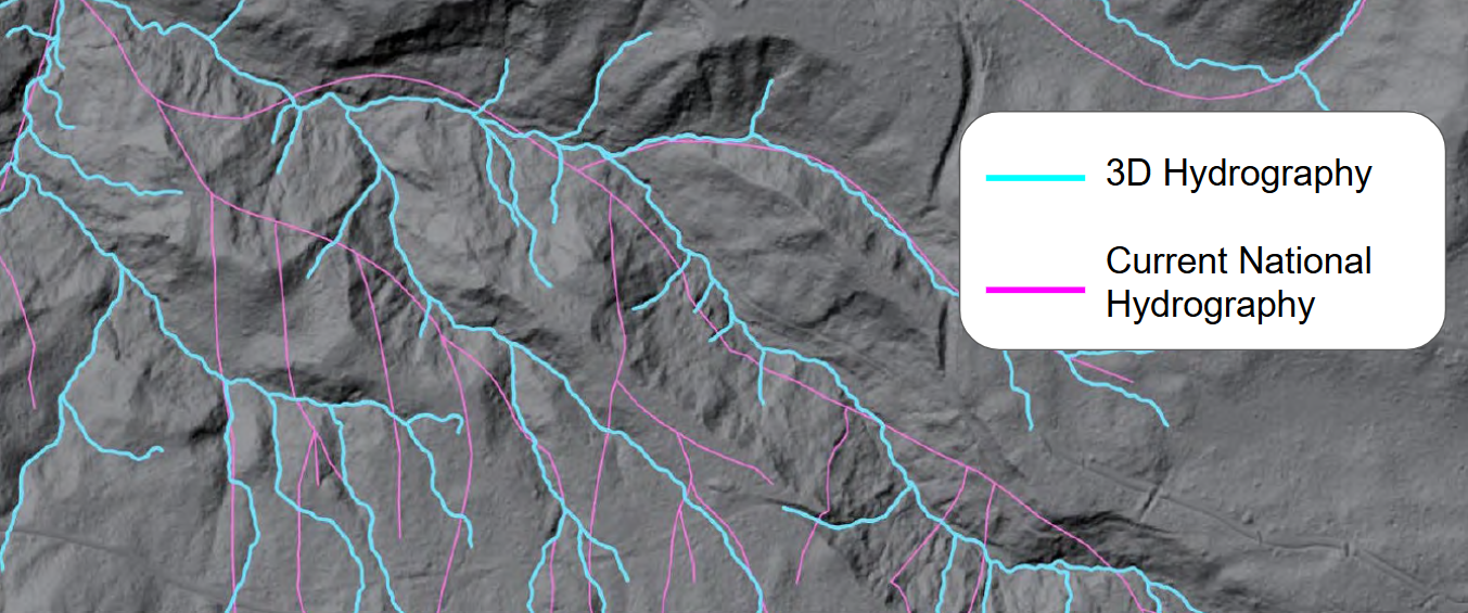
The U.S. Geological Survey (USGS) is now replacing the National Hydrography Dataset, the primary source of stream and ditch maps for more than 20 years, with a new 3D Hydrography dataset. This modern approach uses high-resolution elevation data (LiDAR) to generate significantly more accurate and complete maps.
In 2024, local partners formed the Watercourse Mapping Working Group to apply to the USGS 3D Hydrography Program and raise matching funds. By the end of 2025, the group secured $111,000 and submitted an application to map the entire Gallatin Watershed. This January, the group learned the application was successful, securing an additional $130,000 cost-share from the USGS. Mapping will begin in the spring.
Many thanks to our fiscal partners: USGS, Gallatin Watershed Council, Association of Gallatin Agricultural Irrigators, Gallatin Conservation District, Montana Department of Environmental Quality, Gallatin County, City of Bozeman, U.S. Forest Service, Natural Resources Conservation Service, and the Montana State Library.