Guest column: Gallatin County must regulate for rivers that roam
By Lilly McLane, Guest columnist
Link to Bozeman Daily Chronicle
Recently, the Gallatin County Commission delayed deciding on revisions to the Gallatin County Flood Hazard Management Regulations to consider a broader approach and recommendations proposed by the Gallatin Watershed Council and partners. We appreciate the commission’s willingness to listen, learn, and update rules that proactively manage our watershed and protect the communities that surround our natural waterways.
The Gallatin Watershed Council is recommending that the commission consider including additional watercourse setbacks and restrictions to the removal of riparian vegetation. The purpose of floodplain regulations are to promote public health and safety, and minimize public and private damages due to flooding. Our intent is to acknowledge that the risks associated with flooding and the actions that increase those risks — both on-site and downstream — are not limited to mapped floodplains and that, especially during flood events, intact riparian corridors are critical to protecting both people and property.
There are mapped floodplains for five waterways in Gallatin County: the Gallatin River, the East Gallatin River, and Bridger, Bear, and Bozeman Creeks. Yet all rivers and streams flood. Currently, the standard of safety provided by the floodplain regulations is narrowly applied and impacts are not equitably accounted for.
Rivers move, as do the risks associated with them. The East Gallatin River, for example, according to the East Gallatin Channel Migration Mapping Study, is “very dynamic” with documented migration distances during a 50 year period “typically between 50-100 feet, but in some areas migration measurements between 250 and 400 feet are common.” In many cases, patterns of erosion and avulsion are not within the mapped floodplain boundaries.
Floodplains are mapped by extrapolating on the past. According to the Montana Climate Assessment “a warming climate will strongly influence Montana’s snowpack, streamflow dynamics, and groundwater resources, with far-reaching consequences for social and ecological systems.” With a changing climate, looking to history is not enough, we must also build resilience for the future.
Riparian corridors are one of our biggest and best tools in our toolbox to mitigate flood risk. Complex stands of dense, deep rooting shrubs and trees stabilize stream banks, slow surface runoff, and help dissipate the energy from flood flows. Unfortunately, according to a riparian assessment completed by Montana DEQ, approximately 40% of the stream miles in the Lower Gallatin Watershed lack any contextually appropriate vegetation, almost entirely due to actions that are exempt from the floodplain regulations. Ultimately, the removal of riparian vegetation on tributaries and along larger rivers cumulatively increases flood hazards for landowners and communities downstream.
Given these factors, we recommend the following:
Enact watercourse setbacks that include FEMA mapped floodplains, mapped Channel Migration Zones, Montana Natural Heritage mapped Riparian Areas, and a minimum watercourse buffer. Where a minimum watercourse buffer is defined based on drainage basin area, ranging from 150 feet on streams to 300 feet on rivers.
Require a permit for any large scale removal of riparian vegetation within 50 feet of the high water mark.
Apply watercourse setbacks and restrictions to riparian vegetation removal to all waterways in Gallatin County.
Exempt restoration projects and irrigation diversion maintenance from more restrictive regulation.
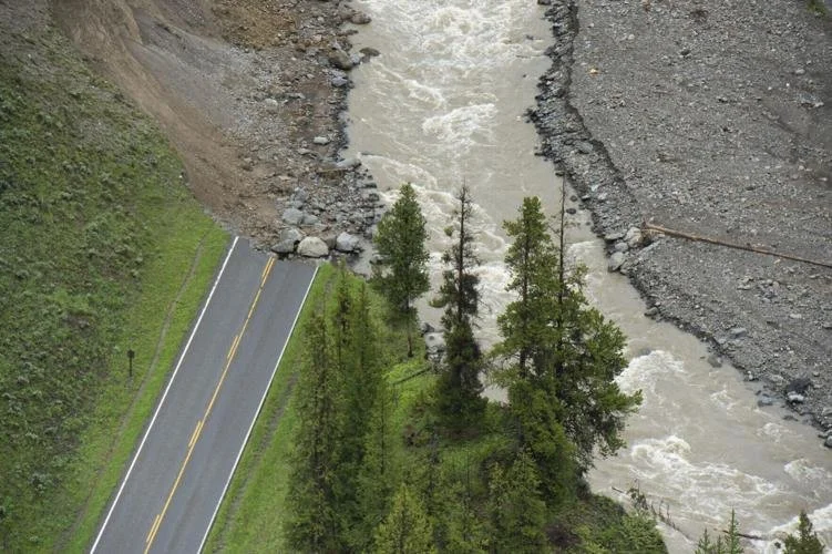
NE Entrance Road disappears into Soda Bute Creek in Yellowstone National Park on Sunday, June 19, 2022.
Many Montanans lost their homes, businesses, and revenue in the Yellowstone flood, as the water swelled into the river’s historical floodplain and beyond, charting new channels and eroding laterally into terraces 10s to 100s of feet outside the floodplain. We have an opportunity to learn from our neighbors and be proactive in the Gallatin Watershed.
Implementing these recommendations is consistent with other county policies and local and state priorities. Watercourse setbacks are already enforced in our Subdivision Regulations, and enacting watercourse setbacks more broadly is a goal included in the Gallatin County Growth Policy. State and federal agencies recognize the urgency to act and are mobilizing unprecedented amounts of funding to build flood resilience.
Flooding and channel migration are not a question of “if”, but “when” and “how big.” The Gallatin Watershed Council looks forward to working with Gallatin County to be ready.